
It's that time of year. Snow maps are flying on the internet. Polar vortex chatter is being tossed around like Macy's parade confetti. And Chris Farley El Niño GIFs are lurking around every social media corner. (Under 35? Google "SNL I am El Niño." You're welcome.)
Can we put together another frigid, snow-stacked winter like last year? Or will all these variables conspire to deliver something completely different? Let's dig into our annual feast of winter conjecture before washing it down with all the Thanksgiving fixings next week!
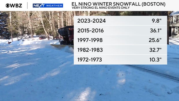
Let's not bury the lede – this expected to be the strongest El Niño event on record. And Boston has never recorded a colder than average or snowier than average winter when there is a very strong El Niño event underway. Granted, that's only a handful of winters (1972–73, 1982–83, 1997–98, 2015–16 and 2023–24 the more recent ones), but it's a perfect record. There's a first time for everything, but if you like playing the odds, then this alone speaks for itself.
There are plenty of drivers on the weather-pattern highway, but tropical forcing – the heat and rising air pumped out of the tropical Pacific – is the 18-wheeler. Whether it's ENSO (the El Niño–Southern Oscillation), recurving typhoons, or the MJO (Madden-Julian Oscillation), what happens in the tropics often determines what happens elsewhere.
This year's El Niño is very similar to the infamous Chris Farley Niño of 1997–98. It features extremely anomalous warm water off the coast of South America, and that warm pool is very far east. Where El Niño peaks is important because it shifts around where air rises and in turn, where the pattern shifts. A central Pacific El Niño can be quite snowy for us, while an eastern Pacific flavor is typically not.
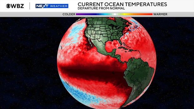
The gist: very warm water produces a lot of rising air. That rising air enhances the Hadley Cell in the eastern Pacific, which in turn energizes the subtropical jet stream. This is the biggest takeaway from El Niño. Models are predicting the strongest subtropical jet stream on record, which would drive a parade of storms across California and through the southern tier of the U.S.
When the subtropical jet stream takes over, the polar jet stream is less of a player. North America gets flooded with a lot of milder Pacific air instead of Arctic air, and the result is milder than average temperatures.
We could be boring and just say that's it; that's the ball game. When it has never been snowier or colder than average during this type of setup, it's hard to bet against the house. But let's play devil's advocate – what could possibly beat the house?
As a refresher, a "strong" polar vortex is when stratospheric winds are blowing strongly around the pole, generally bottling up Arctic air. A "weak" polar vortex is when that flow is feeble and allows the Arctic to release the hounds, so to speak. And a major sudden stratospheric warming (SSW) event is when waves of energy surging up from the lower atmosphere hit the vortex hard enough to knock it off its axis and weaken it enough to reverse its winds, which then blow east to west. The start of this cold season has indeed featured something we haven't seen before – the earliest SSW event on record which took place last week.
The million-dollar question is – will that matter? Often what follows an SSW is a pattern that creates blocking over Greenland and a cold eastern United States.
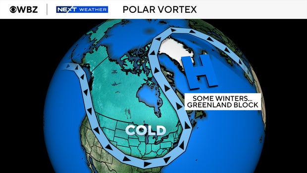
But there are no signs of that happening in the wake of this early disruption. What I think we may see instead is a battle between this unusual occurrence and our record strength El Niño, which could wind up giving us more of a turbulent winter ride than the usual El Niño blast furnace (especially if it suffers another weakening event).
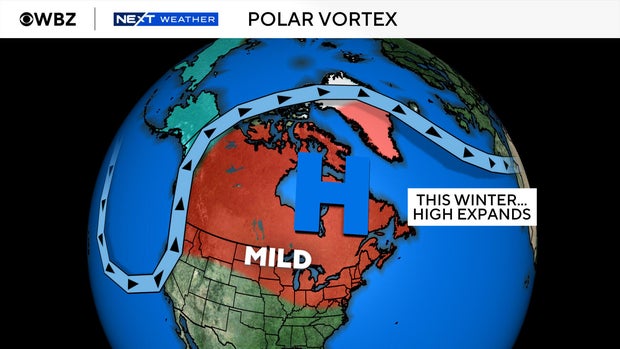
Under strong El Niño conditions in 2023–24 and 2015–16, we absolutely torched our way through December and stayed mild into January and February. In 1997–98 we skipped that really warm December part, staying closer to seasonable. I think this winter may follow that road, as the early polar vortex disruption makes December more changeable than the straight mild-and-wet script. Still milder than average, but not as extreme as 2015.
Do I think the polar vortex will be the main story of this winter? No. But I do think it will introduce some variability versus the typical El Niño script that we otherwise may not have seen.
Usually, we'd work through the supporting cast – the QBO, Atlantic water temperatures and the like – but this year it's a two main character show: El Niño vs. the polar vortex. So let's just move on to the alleged answer key.
You can hit on 18, but I'm not going to. Until we do it for the first time ever, I'll play the better odds and go with below-average snowfall. Let's call it 25–35" in Boston and 45–55" in Worcester (averages are roughly 48" and 73", respectively).
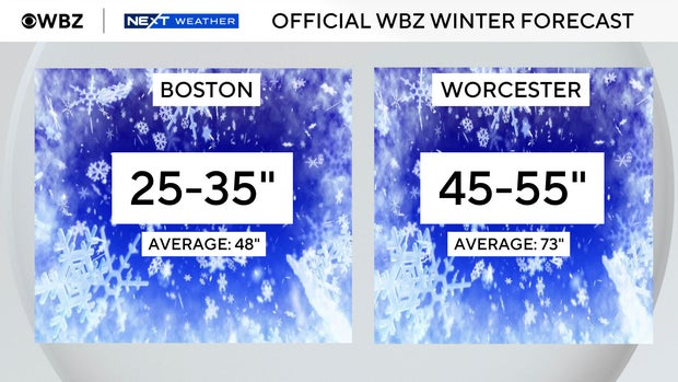
That's on the snowier end of past very strong/Super El Niños – call it the polar vortex wild card built into the number. Yes, a big storm is still possible even in a milder winter, so we will be on the lookout. There should be a significant number of coastal storms lurking about for much of the season. All it takes is timing out even one quick, transient cold shot with a storm and you've got a good one.
Last year I said I only forecast colder than average (in our warming world) when shown significant evidence to support it. And last winter we did in fact see that evidence, and it did indeed verify! This year, I haven't seen it. It would be extremely surprising if the winter as a whole was colder than average in New England. But we will still get some decent transient cold shots from time to time.
Seasonal outlooks are educated guesses made months in advance. Monthly breakdowns are educated guesses with ambition. Nevertheless, we persist.
December: A seesaw, with a solid cold shot or two between warm-ups – not the full El Niño blowtorch.
January: Potential to be the mildest month compared to average.
February: A swing month that's still milder than average, but with a chance to turn volatile again.
I absolutely do not think we lock in long cold stretches this winter like we did last year. So building up ice, keeping snowpack, etc., will be trickier to pull off.
Following this logic, I think the best plan for this ski season is to be flexible and ready to roll when given opportunities. Instead of banking on steady good conditions, be ready to drive north and hit the mountains whenever there's a fresh dump of snow to play on. And mentally prepare for variable good to mush to icy to good again trails over the course of this winter, with plenty of up-and-down temperatures.
Keep the skis waxed and the expectations flexible. And if someone at the base lodge starts shouting "I am El Niño!", you'll know who to blame.


